


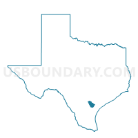
Voting District 0005, Bee County, Texas
About
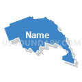
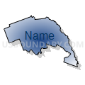
Outline

Summary
| Unique Area Identifier | 670257 |
| Name | Voting District 0005 |
| County | Bee County |
| State | Texas |
| Area (square miles) | 50.57 |
| Land Area (square miles) | 50.54 |
| Water Area (square miles) | 0.03 |
| % of Land Area | 99.93 |
| % of Water Area | 0.07 |
| Latitude of the Internal Point | 28.62461760 |
| Longtitude of the Internal Point | -97.81850880 |
Maps


Graphs
Select a template below for downloading or customizing gragh for Voting District 0005, Bee County, Texas


Neighbors
Neighoring Voting District (by Name) Neighboring Voting District on the Map
- Voting District 0001, Bee County, TX
- Voting District 0002, Bee County, TX
- Voting District 0004, Karnes County, TX
- Voting District 0008, Bee County, TX
- Voting District 0009, Karnes County, TX
- Voting District 0011, Bee County, TX
- Voting District 0012, Bee County, TX
- Voting District 0022, Goliad County, TX
Top 10 Neighboring County Subdivision (by Population) Neighboring County Subdivision on the Map
- Beeville CCD, Bee County, TX (27,429)
- Kenedy CCD, Karnes County, TX (7,281)
- Pettus-Pawnee CCD, Bee County, TX (2,002)
- Goliad South CCD, Goliad County, TX (1,018)
Top 10 Neighboring Place (by Population) Neighboring Place on the Map
Top 10 Neighboring Unified School District (by Population) Neighboring Unified School District on the Map
- Beeville Independent School District, TX (26,742)
- Goliad Independent School District, TX (7,210)
- Kenedy Independent School District, TX (7,058)
- Pettus Independent School District, TX (1,766)
- Pawnee Independent School District, TX (602)
Top 10 Neighboring State Legislative District Lower Chamber (by Population) Neighboring State Legislative District Lower Chamber on the Map
Top 10 Neighboring State Legislative District Upper Chamber (by Population) Neighboring State Legislative District Upper Chamber on the Map
Top 10 Neighboring 111th Congressional District (by Population) Neighboring 111th Congressional District on the Map
Top 10 Neighboring Census Tract (by Population) Neighboring Census Tract on the Map
- Census Tract 9703, Karnes County, TX (7,281)
- Census Tract 9502.02, Bee County, TX (5,059)
- Census Tract 9602, Goliad County, TX (3,156)
- Census Tract 9501, Bee County, TX (2,002)
Top 10 Neighboring 5-Digit ZIP Code Tabulation Area (by Population) Neighboring 5-Digit ZIP Code Tabulation Area on the Map
- 78102, TX (27,593)
- 78119, TX (7,680)
- 77963, TX (5,459)
- 78146, TX (771)
- 78162, TX (375)
- 78107, TX (360)
- 78104, TX (175)